
Pakistan’s Shangri-La turquoise Attabad Lake, the jagged Passu Cones, centuries-old forts, and the Karakoram Highway climbing to Khunjerab Pass, the world’s highest paved border.
Most trips run 5 to 7 days from Islamabad — a 600–650 km, 14–20 hour drive via the Karakoram Highway, or a 1-hour flight to Gilgit followed by a 2–3 hour drive. Budget PKR 45,000–70,000 per person for a group tour with hotel stays, and PKR 90,000–140,000 for a private, customised trip covering Karimabad, Attabad Lake, Passu and Khunjerab Pass. Travel between April and October for the best weather; the Karakoram Highway itself stays open year-round.
Hunza Valley runs roughly 150 kilometres along the Hunza River, from Chalt in the south to the Khunjerab Pass on the Chinese border in the north. Karimabad, the valley’s tourist hub, sits at 2,438 metres beneath Rakaposhi and Ultar Sar. this is Pakistan’s only region where three of the world’s great mountain ranges meet in view of one road.
Khunjerab Pass altitude
From Islamabad by road
Hunza–Gojal valley length
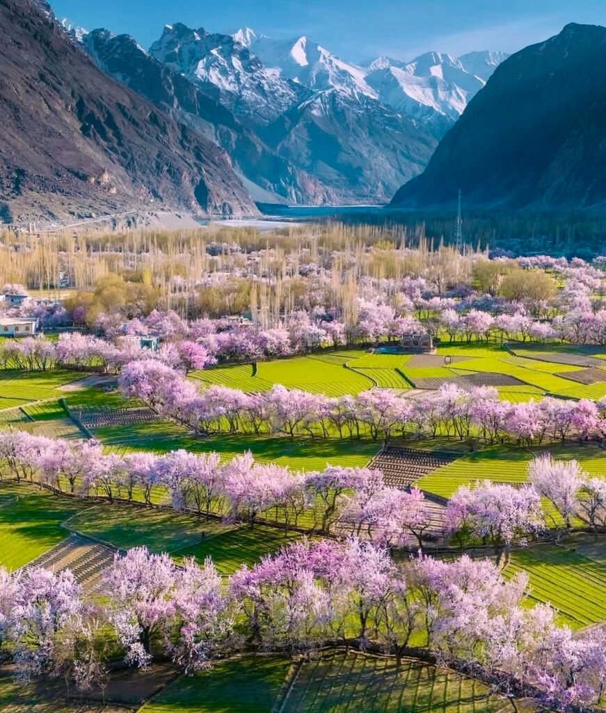
Blossom to golden autumn
Baltit Fort ruled the Hunza princely state for over 700 years before it acceded to Pakistan in 1974. Its 11th-century sister fort, Altit, overlooks the river from a cliff-edge that once served as the Mirs’ first stronghold — both are open to visitors with a local guide included.
In January 2010, a landslide near Attabad village dammed the Hunza River overnight, swallowing a 19-kilometre stretch of highway and creating the turquoise lake that is now Hunza’s most photographed spot.
The Karakoram Highway climbs from Karimabad through Khunjerab National Park home to snow leopards, ibex and Marco Polo sheep. to the 4,733-metre Khunjerab Pass, the physical link between Gilgit-Baltistan and China’s Xinjiang region.
Past Attabad Lake, the valley narrows into Gojal Upper Hunza where the Karakoram Highway threads lakeside tunnels toward Gulmit and Passu. Here the jagged Passu Cones, nicknamed the “Teeth of the World,” rise 6,106 metres straight out of the valley floor.
This stretch is also where Hunza gets genuinely adventurous: the swaying Hussaini Suspension Bridge, the moraine walk to Passu Glacier, and quiet Borith Lake a bird-watching alternative to the busier Attabad are all reachable on a half-day detour from the highway.
Four hours further north, the road ends at Sost, the last town before the Khunjerab immigration post and the Chinese border itself.
The Karakoram Highway (N-35) is the only year-round route to Hunza. Most travellers split the drive over two days, overnighting in Besham, Chilas or Gilgit rather than pushing through in one go.
| Route | Distance | Drive Time | Notes |
|---|---|---|---|
| Karakoram Highway (KKH) | 600–650 km | 14–20 hrs | Open year-round; the most reliable option, especially in winter |
| Naran → Babusar Pass | ~600 km | 12–14 hrs | Shorter and more scenic, but seasonal — Babusar Top is closed roughly Nov–May |
| Flight: Islamabad → Gilgit | ~1 hr flight | +2–3 hrs drive | Fastest option; weather-dependent and seasonal, book flexible tickets |
Hunza valley Tours rewards visitors year-round, but each season shows a different valley. Autumn is the single most photographed season; summer is the most reliable for road access and open attractions.
Cherry and apricot orchards bloom pink and white across Karimabad and Altit. Cool nights, mild days, fewer crowds than summer.
Warmest, clearest weather with daytime highs of 17–32°C. Every attraction and route is open, including Khunjerab Pass and Naran–Babusar.
Widely considered the most scenic season — poplar and apple trees turn gold and crimson against clear, dust-free mountain skies.
Snow-dusted forts and near-empty roads. The KKH stays open, but Khunjerab Pass closes to crossing and temperatures drop well below zero.
By air · Karimabad core
By road · full circuit
Extended · Nagar & Naltar
A 5–6 day group tour from Islamabad typically runs PKR 45,000–70,000 per person, including shared transport, standard hotel stays and daily breakfast and dinner. Private, customised trips with a dedicated jeep and premium hotels range PKR 90,000–140,000 per person. Flying to Gilgit instead of driving adds roughly PKR 22,000–52,000 for airfare.
April–May for blossoms, June–August for warm trekking weather, and late September to mid-November for golden autumn colour — the most photogenic season. The KKH stays open year-round, but Khunjerab Pass typically closes to crossing from December through April.
4 days covers Karimabad's core sights by air. 6–7 days by road adds the full Karakoram Highway drive plus a day trip to Khunjerab Pass and time in Nagar or Naltar Valley. 8+ days lets you add a rest day for altitude.
The core circuit is easy Attabad Lake, both forts and Khunjerab Pass are reached by paved road or a short walk, no trekking required. Hunza sits at 2,400–2,500 m, so mild altitude symptoms are possible; Khunjerab reaches 4,733 m, where they're more common. Optional hikes like Passu Glacier or Baskuchi Top are moderate to strenuous.
Standard inclusions: return transport (road or flights), hotel stays, breakfast and dinner, and a tour guide. Usually excluded: lunch on the road, Attabad Lake boating, the Khunjerab Pass jeep/entry fee, and personal shopping. Confirm the Attabad Tunnel toll and any Nagar/Naltar side trips before booking.
Yes Hunza is consistently rated one of the safest, most tourist-developed regions in Pakistan, with established hotels, a paved highway and a well-worn tourist circuit. Main precautions: rest on arrival day for altitude, avoid night driving, and take the Attabad Tunnel section slowly during monsoon landslide risk.
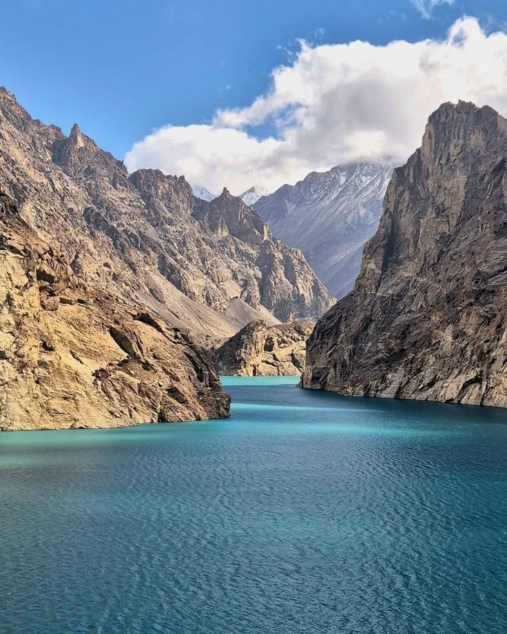
Turquoise water formed by a 2010 landslide, now Hunza's signature photo stop, with boating and jet-ski rides.
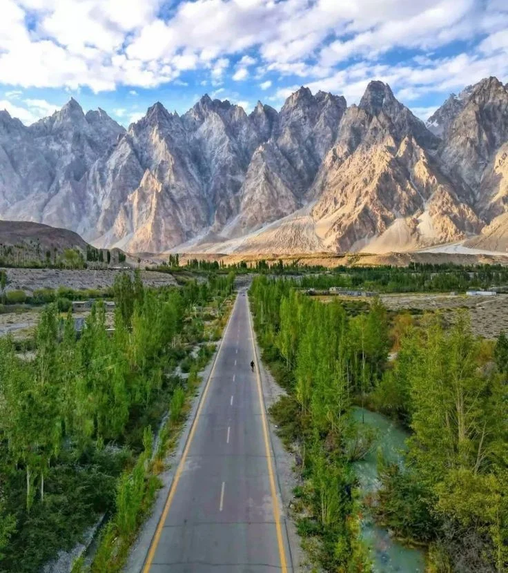
The jagged "Teeth of the World" 6,106 m peaks rising straight from the highway, best photographed at golden hour.
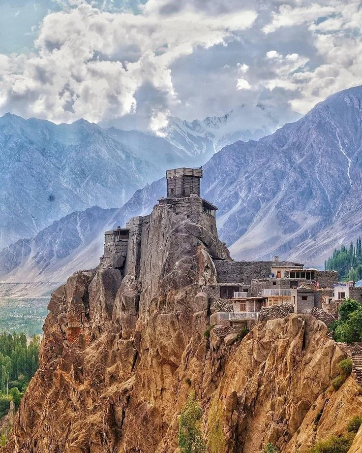
A 700-year-old fort that ruled the Hunza princely state, with guided tours through its royal chambers and museum.
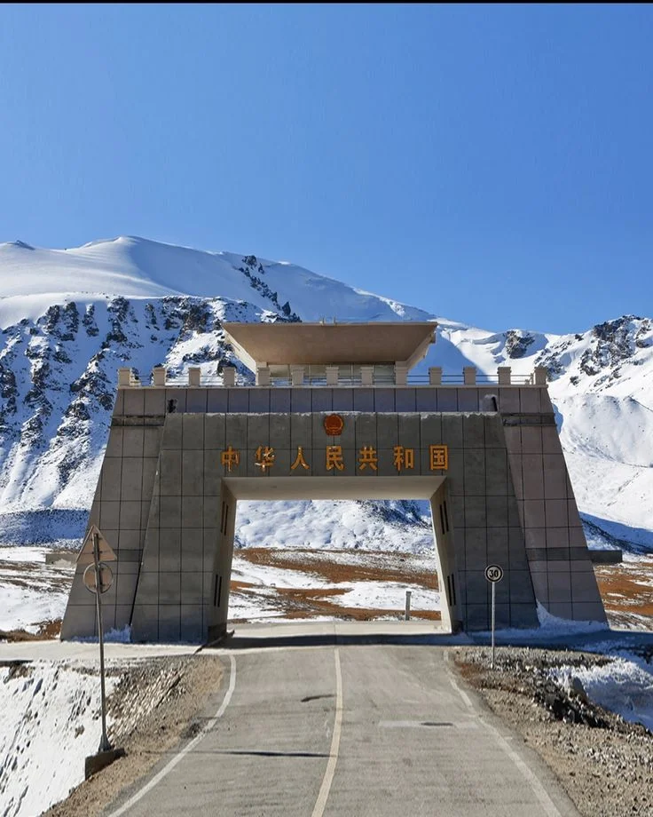
The world's highest paved border crossing at 4,733 m, linking Pakistan to China through Khunjerab National Park.
Hunza swings between warm days and cold nights year-round, and altitude at Khunjerab Pass makes layering essential even in summer.
Pakistani travellers need only an original CNIC. Foreign nationals should carry their passport at all times and check current NOC requirements for Khunjerab National Park before travelling.
Karimabad sits at 2,438 m and Khunjerab Pass at 4,733 m. Rest on arrival, stay hydrated, and turn back if you experience severe headache, nausea or breathlessness at the pass.
Mobile coverage is reliable in Karimabad and Gilgit but patchy or absent in Gojal and near Khunjerab. Download offline maps before you leave Gilgit.
ATMs exist in Gilgit and Karimabad but are unreliable further north. Carry enough cash for Passu, Sost and Khunjerab before heading past Attabad Lake.
The KKH is well-paved but narrow in places. Avoid night driving, and build in a weather buffer during the July–August monsoon, when landslides are more likely on lower sections.
Hunza is progressive and welcoming, but dress modestly, ask before photographing people, and always ask permission before entering private orchards or homes.
Straight answers to the questions that come up most before a Hunza trip — from permits to packing for altitude.
No special NOC is needed to visit Karimabad, Attabad Lake, Gulmit, or Passu — a standard Pakistani tourist visa covering Gilgit-Baltistan is enough. A separate permit is only required if you're continuing past Sost toward Khunjerab Pass or the China border zone, and our team arranges this in advance for guests who add it to their itinerary.
Coverage is reliable in Karimabad and Gilgit (Telenor, Zong, SCOM), but gets patchy past Gulmit and near Khunjerab Pass. Foreign visitors can only buy an SCOM SIM from a franchise store in Gilgit or Karimabad — we recommend downloading offline maps before heading further north.
Yes — the Karakoram Highway stays open year-round and Karimabad remains accessible through winter. Khunjerab Pass typically closes to crossing from December to April, and some upper-valley guesthouses close for the season. Winter rewards travellers with snow-covered forts, frozen waterfalls, and empty roads.
ATMs exist only in Gilgit and Karimabad, and are often out of service during peak season — there are none in Passu, Sost, or near Khunjerab. Withdraw enough PKR cash before heading past Attabad Lake, and keep small denominations (100/500/1,000) for roadside stops.
Yes — Hunza is widely regarded as one of the safest and most welcoming regions in Pakistan for women travelling alone, with an established tourist circuit and genuinely hospitable local culture. Standard precautions apply: avoid night travel on mountain roads, dress modestly, and ask permission before photographing locals.
Karimabad sits at 2,438m and rarely causes issues, but Khunjerab Pass at 4,733m can bring mild headache, nausea, or breathlessness for some travellers. We build in a rest day on arrival, keep guests hydrated, and turn back if symptoms are severe.
Karimabad is the main base, with the widest choice of hotels and easiest access to Baltit and Altit Forts. Passu and Gulmit suit travellers prioritising Attabad Lake and the Passu Cones with a quieter upper-valley stay. Most of our itineraries split 2–3 nights in Karimabad with 1–2 nights further north.
For most travellers, yes. It's the world's highest paved international border crossing at 4,733m, bordering Khunjerab National Park where you may spot yaks, ibex, and Marco Polo sheep. It's a full-day round trip (7–8 hours) from Karimabad — genuinely worth it for the scenery and altitude experience, though it can be skipped on shorter 4-day itineraries.

We make your journey to Northern Pakistan simple, safe and unforgettable — Hunza, Skardu, Swat, Naran & Kaghan, Naltar, Murree and Azad Kashmir, planned by local, licensed guides.
+92 308 5223335
info@toursbynature.com
Office No.1, Plot No. 2-E, Chaudhary Market, I-9/4, Islamabad, Pakistan
toursbynature.com
Welcome to Tours by Nature!
Thank you for reaching out — we’re excited to help you plan your perfect journey
WhatsApp Us
Online | Privacy policy
Book Now